AutoCAD Map Tools
The AutoCAD Map toolkit consists of a number of tools that are provided for use with AutoCAD Map only. They will not work in plain AutoCAD or BricsCAD.
 Toolbar : AutoCAD Map Tools
 ![]()
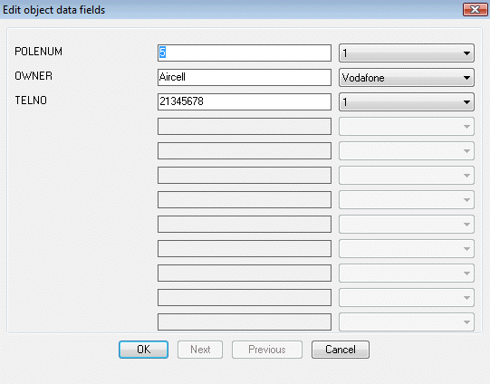
Menu : GeoTools -> AutoCAD Map Tools -> Edit object data from AutoCAD Map  CmdLine : GT_BC_ODEDIT
Description pending
Toolbar : AutoCAD Map Tools 
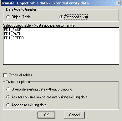
Menu : GeoTools -> AutoCAD Map Tools -> Data Convert/Transfer -> Transfer object data / xdata between two objects CmdLine : GT_XFER_OD_XD
The GT_XFER_OD_XD command is used to set the parameters for transfer of object table and/or extended entity data from one object to another.
Watch: ![]()
Toolbar : AutoCAD Map Tools ![]()
Menu : GeoTools -> AutoCAD Map Tools -> Data Convert/Transfer -> Transfer object data between two objects CmdLine : GT_XO
The GT_XO command actually performs the transfer between two selected objects based on GT_XFER_OD_XD settings.
Toolbar : AutoCAD Map Tools 
Menu : GeoTools -> AutoCAD Map Tools -> Data Convert/Transfer -> Export object table data as block attributes CmdLine : GT_OD2ATT / GT_ODA
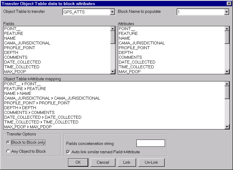
The GT_OD2ATT command is used to set the parameters for transfer of object data to block attributes.
The GT_ODA command performs the actual transfer.
Once the object data table and the block name are selected, the object data fields and the corresponding block attributes need to be linked or associated. Multiple mapping is possible viz. more than one object table data can be mapped to the same attribute value.
Transfer Options:
Block to Block only: Brings up a selection box to select only blocks. The object table data is directly transferred from each selected block to its own attributes as per the mapping specified above.
Any Object to Block: Choosing this option allows a manual method of operation for this command using the GT_ODA command. This allows any object to be selected and its object data is transferred to a selected block whose name and attribute mapping etc. are specified in this dialog box.
Toolbar : AutoCAD Map Tools 
Menu : GeoTools -> AutoCAD Map Tools -> Data Convert/Transfer -> Export block attributes as object table data CmdLine : GT_ATT2OD / GT_AOD
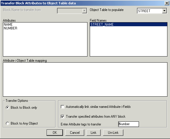
The GT_ATT2OD command is the opposite of GT_OD2ATT and is used to transfer Block Attribute information to AutoCAD Map Object Data.
Once the block name and object data table are selected, the block attributes and the corresponding object data fields need to be linked or associated. Multiple mapping is possible viz. more than one attribute can be mapped to the same object data.
Transfer Options:
Block to Block only: Brings up a selection box to select only blocks. The attributes are directly transferred from each selected block to its own object table as per the mapping specified above.
Block to Any Object: Choosing this option allows a manual method of operation using the GT_AOD command.
Transfer specified attributes from ANY block->: Checking this option allows two or more differently named blocks with similarly named attribute tags to be used for the transfer of attributes to object table data. Disabling this option causes only blocks matching the specified name AND tag to be selected for the transfer.
Toolbar : AutoCAD Map Tools 
Menu : GeoTools -> AutoCAD Map Tools -> Data Convert/Transfer -> Transfer database linked data to object data. CmdLine : GT_DB2OD
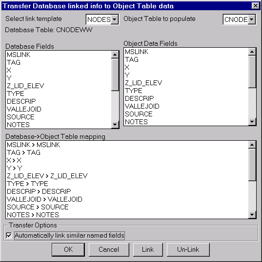
The GT_DB2OD command is used to transfer CAO-linked database information to AutoCAD Map object table data. The transfer is made based on a mapping of database fields to object data fields. The database must be linked via link templates (CAO).
Important Note: (for non-English language AutoCAD / OS only) : There is possibly a bug you can encounter while running non-English language versions of AutoCAD which prevents this command from running correctly. It appears that AutoCAD is unable to read the CAO (Connectivity Automation Object) type library from the folder "C:\Program Files\Common Files\AutoCAD Shared\" in non-English AutoCAD/OS versions. To fix this problem, please copy the 'cao???16.tlb' type library files to the folder where acad.exe is residing
Toolbar : AutoCAD Map Tools 
Menu : GeoTools -> AutoCAD Map Tools -> Data Convert/Transfer -> Convert Object Table Data to Xdata CmdLine : GT_OD2XD
The GT_OD2XD command transfers AutoCAD Map Object Table data to Xdata. This could be useful when you want to make object data information available to someone who has only plain AutoCAD and not AutoCAD Map.
Toolbar : AutoCAD Map Tools 
Menu : GeoTools -> AutoCAD Map Tools -> Data Convert/Transfer -> Transfer AutoCAD properties to object data CmdLine : GT_PROP2OD
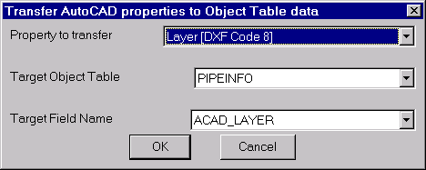
The GT_PROP2OD command allows AutoCAD entity properties to be transferred into object data.
Property to transfer: The following properties can be transferred, where applicable.
Basic properties:
Insertion point (DXF Code 10)
Entity Type (DXF Code 0)
Text String Value (DXF Code 1)
Block,Shape Name (DXF Code 2)
Handle (DXF Code 5)
Linetype (DXF Code 6)
Text Style (DXF Code 7)
Layer (DXF Code 8)
DXF Code 11
DXF Code 12
DXF Code 13
Thickness (DXF Code 39)
Radius[arc,circle]/Text Height (DXF Code 40)
Rotation Angle (DXF Code 50)
Color (DXF Code 62)
Flag (DXF Code 70)
Derived properties:
Elevation[Z] from DXF Code 10
Length of lines/polylines/arcs/splines
Toolbar : AutoCAD Map Tools 
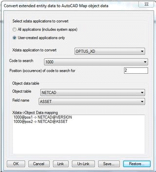
Menu : GeoTools -> AutoCAD Map Tools -> Data Convert/Transfer -> Convert Xdata to Object Table Data (generic tool) CmdLine : GT_XD2OD
The GT_XD2OD command is yet another generic data conversion tool in GeoTools/CADPower. Using this, you can convert extended entity data to AutoCAD Map object data.
To make it easy for you to understand and try this feature, here is a sample drawing Sortedpoly.DWG with which you can try this command .
Here is an example of XDATA record structure from the sample DWG comprising of 33 records from a GPS data logging device.
(-3 ("GPS_BLOCK"
(1000 . "Tunis to Tarheel")
(1000 . "11/13/01")
(1000 . "03:42:46pm")
(1040 . 48.0)
(1070 . 0)
(1000 . "bxr101")
(1040 . 12.0)
(1000 . "Synergy")
(1040 . 0.312)
(1000 . "X42")
(1000 . "Steel")
(1000 . "")
(1040 . 2.9)
(1000 . "Differential")
(1000 . "Pro XR")
(1000 . "11/13/01")
(1000 . "04:42:46pm")
(1000 . "New")
(1000 . "Weld")
(1000 . "R1112SE1.cor")
(1000 . "7")
(1000 . "7")
(1000 . "ENCNG Transmission")
(1070 . 1140)
(1040 . 247379.0)
(1000 . " ")
(1040 . 0.0)
(1040 . 0.452)
(1040 . 9.1e-005)
(1040 . 955479.0)
(1040 . 2.60323e+006)
(1070 . 74)
)
)
Notice that all XDATA is stored in codes. Some of the common codes used like 1000 & 1001 are string codes, 1040 is a floating point value and 1070 is an integer.
We need to transfer this info into object data. So, we create a object table to hold this information and its structure looks like this (see below).
(
("SUB_PROJECT_NUMBER" "SUB_PROJECT_NUMBER" "Character" "")
("DATE_INSTALLED" "DATE_INSTALLED" "Character" "")
("TIME_COLLECTED" "TIME_COLLECTED" "Character" "")
("DEPTH" "DEPTH" "Real" 0.0)
("WELD_NUMBER" "WELD_NUMBER" "Integer" 0)
("X-RAY_REFERENCE_NUMB" "X-RAY_REFERENCE_NUMB" "Character" "")
("NOMINAL_DIAMETER" "NOMINAL_DIAMETER" "Real" 0.0)
("COATING" "COATING" "Character" "")
("WALL_THICKNESS" "WALL_THICKNESS" "Real" 0.0)
("GRADE" "GRADE" "Character" "")
("MATERIAL" "MATERIAL" "Character" "")
("COMMENTS" "COMMENTS" "Character" "")
("MAX_PDOP" "MAX_PDOP" "Real" 0.0)
("CORR_TYPE" "CORR_TYPE" "Character" "")
("RCVR_TYPE" "RCVR_TYPE" "Character" "")
("GPS_DATE" "GPS_DATE" "Character" "")
("GPS_TIME" "GPS_TIME" "Character" "")
("UPDATE_STATUS" "UPDATE_STATUS" "Character" "")
("FEAT_NAME" "FEAT_NAME" "Character" "")
("DATAFILE" "DATAFILE" "Character" "")
("UNFILT_POS" "UNFILT_POS" "Character" "")
("FILT_POS" "FILT_POS" "Character" "")
("DATA_DICTIONARY_NAME" "DATA_DICTIONARY_NAME" "Character" "")
("GPS_WEEK" "GPS_WEEK" " "Integer" 0)
("GPS_SECOND" "GPS_SECOND" "Real" 0.0)
("GPS_HEIGHT" "GPS_HEIGHT" "Character" "")
("VERT_PREC" "VERT_PREC" "Real" 0.0)
("HORZ_PREC" "HORZ_PREC" "Real" 0.0)
("STD_DEV" "STD_DEV" "Character" "")
("NORTHING" "NORTHING" "Real" 0.0)
("EASTING" "EASTING" "Real" 0.0)
("POINT_ID" "POINT_ID" "Integer" 0)
)
Since XDATA is not stored as a table with a field structure, it is necessary to specify the xdata in terms of the xdata codes (100,1040 etc) and the position (occurrence) of the code from the start of the XRECORD.
If you want to transfer the XDATA item "Time Collected" to object data, it must be specified as the 3rd occurrence of the 1000 field.
In other words, you choose the XDATA code as 1000 and the occurence as 3. After that, you specify the object table and the field to which this must be mapped.
Once you have setup all such mapping between the xdata records and the object data, the program will transfer the xdata to object data accordingly from all selected objects as long as the correct expected structure is mainatained in all the objects.
Please be aware that the type of the XDATA field must match the type of the object data field for the transfer map to be valid and successful. For example, character XDATA codes 1000 and 1001 can be linked to character object fields only, 1040 can link to floating point field only and 1070 can link to integer data field only.
Toolbar : AutoCAD Map Tools 
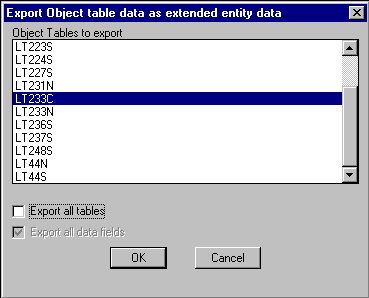
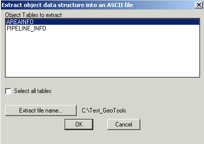
Menu : GeoTools -> AutoCAD Map Tools -> Export -> Export object table data to ASCII files CmdLine : GT_OD_EXTRACT
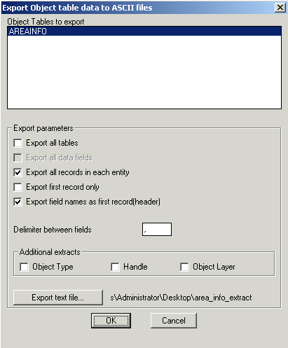
The GT_OD_EXTRACT command is used to export AutoCAD Map Object Table data as ASCII text files. The ASCII format of the exported data is generic and designed in such a way that any third-party program can be written to read the information from this file without difficulty
Toolbar : AutoCAD Map Tools 
Menu : GeoTools -> AutoCAD Map Tools -> Export -> Extract object table structure to a text file CmdLine : GT_OD_STRUCEXT
GT_OD_STRUCEXT command is used to extract the field structure of an object table into an ASCII text file. When you have multiple object tables in your drawing and want to review or compare the structure, this is quite useful.
Toolbar : AutoCAD Map Tools 
Menu : GeoTools -> AutoCAD Map Tools -> Create -> Create automatically incrementing object data CmdLine : GT_AUTOINCROD
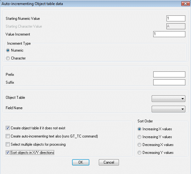
The GT_AUTOINCROD command is used to sequentially assign object data to objects, one after the other.
This command is very similar to the GT_TC command except that it creates auto-incrementing object data rather than auto-incrementing text objects. This command can be linked to the GT_TC command internally (and run GT_TC) and thus create auto-incrementing text objects along with object data.
Toolbar : AutoCAD Map Tools 
Menu : GeoTools -> AutoCAD Map Tools -> Create -> Create text labels from object data / extended entity data CmdLine : GT_OD_XD_LABEL
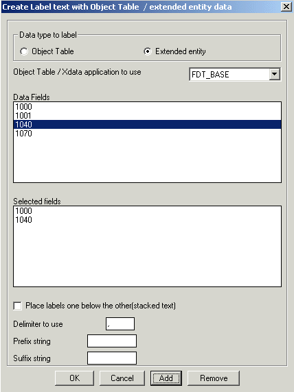
The GT_OD_XD_LABEL command creates text labels from object data or xdata. The labels can be created using multiple fields with specified prefixes, suffixes etc.
In the case of extended entity data, the fields are specified based on their DXF codes applicable to xdata. The following DXF codes are allowed for labeling: 1000 (string), 1001 (string), 1040 (real) and 1070 (integer). The same xdata code can be chosen multiple times in any order. However, this order must be as per the order of xdata fields in the objects being processed.
Toolbar : AutoCAD Map Tools 
Menu : GeoTools -> AutoCAD Map Tools -> Object Data -> Global object data editor CmdLine : GT_OD_EDIT
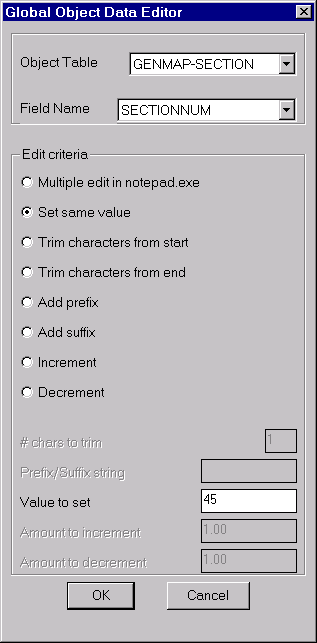
The GT_OD_EDIT command is used to globally edit object data values in the current drawing. Several Edit criteria can be applied on the data as shown in the dialog box. When no apparent criteria are applicable and you need to collectively make some arbitrary changes to the object data, you can choose the Multiple edit in notepad.exe option. This would bring up the selected object data in notepad.exe editor. Upon save and exit, the changes are reflected in the object data.Toolbar : AutoCAD Map Tools 
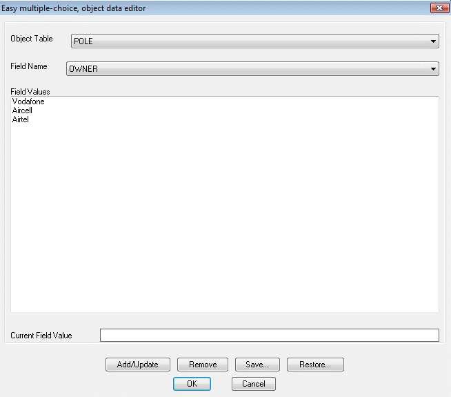
Menu : GeoTools -> AutoCAD Map Tools -> Object Data -> Multiple-Choice object data editor CmdLine : GT_EASYOD
The GT_EASYOD command makes entry or editing of object data easier by offering a pre-defined, configurable set of values for each object data field, selectable from a drop-down list.
There is also a setup command called GT_EASYOD_SETUP provided which allows the table names / field names / field values to be specified and optionally saved into ASCII INI files, which can be restored in a later session of AutoCAD.
Toolbar : AutoCAD Map Tools 
Menu : GeoTools -> AutoCAD Map Tools -> Object Data -> Multiple-Choice object data editor Setup CmdLine : GT_EASYOD_SETUP
The GT_EASYOD_SETUP command allows the table names / field names / field values to be specified and optionally saved into ASCII INI files, which can be restored in a later session of AutoCAD.
Toolbar : AutoCAD Map Tools 
Menu : GeoTools -> AutoCAD Map Tools -> Object Data -> Merge two object tables CmdLine : GT_MERGETBL
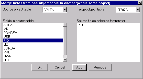
The GT_MERGETBL command allows fields from one object table to be transferred to another object table. Both tables must be attached to the same object. Using this, entire object tables can be merged, if required. For example, if you have object tables A and B and wish to create a third table C that contains all fields of A and B, you can accomplish this using GT_MERGETBL.
Toolbar : AutoCAD Map Tools 
Menu : GeoTools -> AutoCAD Map Tools -> Object Data -> Remove duplicate or multiple records from object tables CmdLine : GT_REM_DUP_RECS
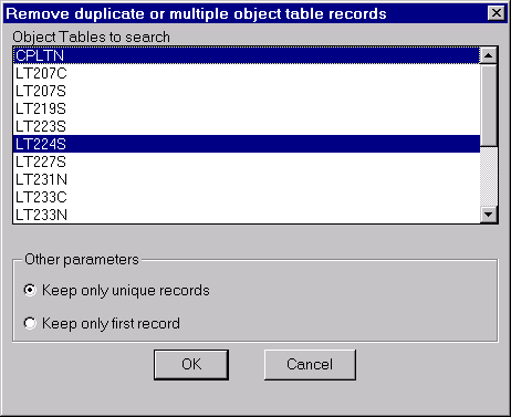
The GT_REM_DUP_RECS command removes duplicates object table records. It can also be used to remove multiple object table records and retain only one record.Toolbar : AutoCAD Map Tools 
Menu : GeoTools -> AutoCAD Map Tools -> Object Data -> Rename object data fields CmdLine : GT_REN_OD_FLDS
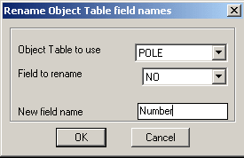
The GT_REN_OD_FLDS command is used to rename object data field names
Toolbar : AutoCAD Map Tools 
Menu : GeoTools -> AutoCAD Map Tools -> Object Data -> Assign elevations from object data CmdLine : GT_OD2ELEV
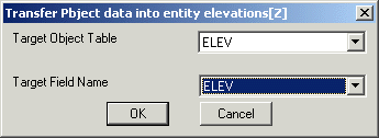
The GT_OD2ELEV command allows transferring a real or integer value object table data into the elevation [Z] of selected drawing entities. The entities that can accept an elevation value are points, lines, arcs, polylines, shapes and blocks
Toolbar : AutoCAD Map Tools 
Menu : GeoTools -> AutoCAD Map Tools -> Object Data -> Transfer text strings to object data CmdLine : GT_TXT2OD
The GT_TXT2OD command is used to transfer text data into object data.
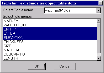
The GT_TXT2OD command is used to transfer text strings as object data. Using this command, you can select an object table name and specify the field(s) to populate. You then select a text object for each field and the text string is transferred as object data.
Toolbar : AutoCAD Map Tools 
Menu : GeoTools -> AutoCAD Map Tools -> Object Data -> List object data CmdLine : GT_OD_LIST
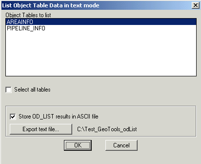
The GT_OD_LIST command displays object data from selected objects in the AutoCAD text screen. Think of it as the good-old AutoCAD LIST command for object data. Additionally, the output can be exported to ASCII files.
Toolbar : AutoCAD Map Tools 
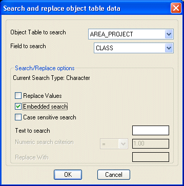
Menu : GeoTools -> AutoCAD Map Tools -> Object Data -> Search and replace object data CmdLine : GT_OD_SEARCH
The GT_OD_SEARCH command is used to search and replace object table data. Depending on the field type (Field to search, a numeric or character search is carried out.
Toolbar : AutoCAD Map Tools 
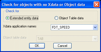
Menu : GeoTools -> AutoCAD Map Tools -> Object Data -> Checks for No Xdata / Object data CmdLine : GT_NODATA
GT_NODATA command is used to identify objects in the drawing that do not contain any object data or extended entity data belonging to selected object tables or application names respectively. This is useful in QA/QC procedures.
Toolbar : AutoCAD Map Tools 
Menu : GeoTools -> AutoCAD Map Tools -> Object Data -> Break object but retain object data in broken parts CmdLine : GT_AMAPBREAK
The GT_AMAPBREAK command works exactly like the AutoCAD Break command but it ensures that both the broken parts of the object retain their object data.
Toolbar : AutoCAD Map Tools 
Menu : GeoTools -> AutoCAD Map Tools -> Object Data -> Copy object table definition CmdLine : GT_COPYODTABDEF
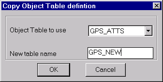
The GT_COPYODTABDEF command copies one object table into another with identical field structure.
Toolbar : AutoCAD Map Tools 
Menu : GeoTools -> AutoCAD Map Tools -> Object Data -> Define object table from block attributes CmdLine : GT_DEFATTOD
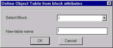
The GT_DEFATTOD command is used to create an object table using block attribute tags as the object data field names.
Toolbar : AutoCAD Map Tools 
Menu : GeoTools -> AutoCAD Map Tools -> Object Data -> Define block attributes from object table CmdLine : GT_DEFODATT
The GT_DEFODATT command is used to create a block with attributes out of field names from a selected object table.
Toolbar : AutoCAD Map Tools 
Menu : GeoTools -> AutoCAD Map Tools -> Object Data -> Define object table from linked database data CmdLine : GT_DEFDBOD
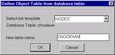
The GT_DEFDBOD command is used to create an object table using the names and types of fields in a CAO-linked database table.
Toolbar : AutoCAD Map Tools 
Menu : GeoTools -> AutoCAD Map -> Define object data CmdLine : GT_ADEDEFDATA
Description Pending
Toolbar : AutoCAD Map Tools 
Menu : GeoTools -> AutoCAD Map -> Attach/Detach object data CmdLine : GT_ADEATTACHDATA
Description Pending
Toolbar : AutoCAD Map Tools 
Menu : GeoTools -> AutoCAD Map -> Edit object data CmdLine : GT_ADEEDITDATA
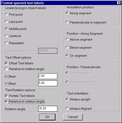
The GT_QUERYPROC command is used to format the labels created during an AutoCAD Map query process with the 'Alter Properties' option. The way AutoCAD Map displays the labels after a query does not allow flexible positioning and formatting of the label text. The GT_QUERYPROC command attempts to fill that gap by allowing different ways to position the text labels immediately following the execution of the query.
The two main types of objects that can be queried are point features (AutoCAD points, blocks, text) and linear/polygonal objects (lines, polylines, splines, 3dfaces etc).
Toolbar : AutoCAD Map Tools 
Menu : GeoTools -> AutoCAD Map Tools -> Select topology objects graphically CmdLine : GT_TOPOSELECT
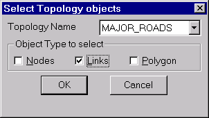
The GT_TOPOSELECT command creates a selection set of topology objects and places them in the active [previous] selection set.