Selection Tools
 Toolbar : Selection Tools
Menu : GeoTools -> Selection -> Polylines based on properties CmdLine : GT_PLFILTER
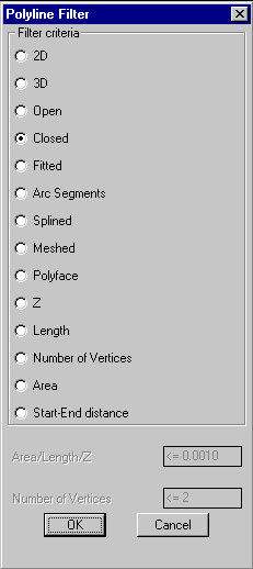
Filters polylines based on their properties.
The following properties of polylines can be filtered from the selection set.
|
2D |
3D |
Open |
|
Closed |
Fitted |
Arced |
|
Splined |
Meshed |
Polyface |
|
Z value |
Length |
Number of vertices |
|
Area |
Start-End Distance |
|
The length, area, number of vertices or start-end distances are specified by entering < n, <= n, > n, >= n, = n, /= n where "n" is the value to check for.
Specify the numeric logical comparative operator in one of these ways.
< 'Value' - Less than 'Value'
<= 'Value' - Less than or equal to 'Value'
> 'Value' - Greater than 'Value'
>= 'Value' - Greater than or equal to 'Value'
= 'Value' - Equal to 'Value'
/= 'Value' - Not Equal to 'Value'
Enter Length / Area / Z criteria: <= 55.0
This would select all objects with the specified property less than or equal to 55.0
Notes: The Start-End distances are always measured in slope in the case of 3d polylines. The Z value check will fail if there is even one vertex in the polyline that fails to meet the criterion.
Toolbar : Selection Tools 
Menu : GeoTools -> Selection -> Enhanced Entity Selector CmdLine : GT_ESELECT
The GT_ESELECT command allows the Fence, CrossingPoly [CP] and WindowPoly [WP] selection modes to be applied automatically along multiple polylines which serve as boundaries for the selection.
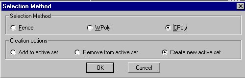
Once the boundary polylines for selection are specified, the command zooms to each polygon and applies the selection mode. The results of selection from each polyline are combined and placed in the active selection set. This command can be used along with the GT_MAKESEL command to build very powerful selection filters.Toolbar : Selection Tools 
Menu : GeoTools -> Selection -> Build Selection Set CmdLine : GT_MAKESEL
Toolbar : Selection Tools 
Menu : GeoTools -> Selection -> Find objects in selected Z range CmdLine : GT_FINDZRNG
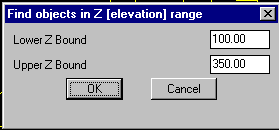
The GT_FINDZRNG command selects all objects whose Z values fall within a specified range. This is a useful QA / QC tool.
Toolbar : Selection Tools 
Menu : GeoTools -> Selection -> Select current layer CmdLine : GT_SL
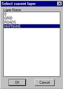
The GT_SL command selects an entity and make its layer the current layer. Alternately, you can choose layers from a dialog box
Toolbar : Selection Tools 
Menu : GeoTools -> Selection -> Select current style CmdLine : GT_SS
Select a text and make its style the current text style. Alternately, you can choose available styles from a dialog box.
Toolbar : Selection Tools 
Menu : GeoTools -> Selection -> Put last GeoTools selection in [active] 'previous' selection set CmdLine : GT_LASTSEL
The GT_LASTESEL command retrieves the last created or processed objects by a GeoTools command and places them in internal memory as well as in the active [previous] selection set. The active selection may be overwritten at any time using other selection commands, but the last processed results of a GeoTools command are always “remembered” by this command and can always be brought back to active selection using this command.